


News
YES | 1 | YES
Nauru to conduct survey on every well in the country
04 March, 2010
Yaren, Thursday March 4, For the first time ever, a survey of every well in Nauru will be conducted in order to determine water quality, usage, and possible areas of contamination.
Nauru has no significant surface water resources, limited groundwater resources, and is extremely vulnerable to drought.
Water for domestic use comes from a mixture of desalinated supply delivered by truck, rainwater harvested from roofs, non-potable coastal groundwater, seawater and limited use of the thin freshwater lens found under Nauru’s central plateau.
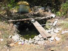
Current estimates that between 600 to 700 households on Nauru rely on water from wells for cooking, bathing and other needs. There are concerns that the water in these wells is either brackish or susceptible to contamination.
The Government of Nauru, in conjunction with the Pacific Island Applied Geoscience Commission (SOPAC), is therefore carrying out a survey of household wells in order to know how many people use well water and the water quality of each well in order to promote safe use and development of the water resource.
“This survey will provide important information, collected for the first time, on how many domestic wells there are and the quality of the groundwater in Nauru,” said Haseldon Buraman, Integrated Water Resource Management Project Officer at Commerce Industry and Environment (CIE). “The information collected will help us better guide water resource planning in Nauru.”
Survey teams comprising of staff from the Ministry of Health, CIE, and SOPAC will visit wells to measure water salinity and test for bacteria. The survey will also collect information from households on who uses well water and what for. Risks and threats such as pollution sources will also be recorded for each well.
“We recognise that shallow well water is a resource which the community relies upon and is therefore important,” said Peter Sinclair, Project Advisor and Hydro-geologist with SOPAC’s Pacific Hydrological Cycle Observing System (HYCOS). “What the survey will attempt to do is quantify this reliance in terms of numbers of wells, water usage, extraction methods, and water quality as a snap shot. These results can then be used to determine the safety and best use of well water.”
District based workshops will be held in the weeks after completion of the survey to provide information back to well users. This information will help households make improvements to reduce risks to their water with simple measures, such as fencing, covering wells and removing potential sources of pollution.
The survey will commence on Monday 8th March. It is expected that the survey will take 3-5 weeks to complete.
For more information please contact
Haseldon Buraman Commerce Industry and Environment +674 5573117
Peter Sinclair SOPAC HYCOS Project Advisor - +674 5567698
Tiy Chung SOPAC Communications Advisor: +679 9987586
