GEOSCIENCE DIVISION
Map Cook Islands Federated Sates of Micronesia Fiji Kiribati Nauru Niue Papua New Guinea Republic of Marshall Islands Republic of Palau Samoa Solomon Islands Tonga Tuvalu Vanuatu
Country
Population
Land Area
Climate
Water resource
Water consumption
Country Cook Islands Cook Islands
Population 21,750 (July 2007 est.)
Land Area 236.7 km2
Climate
Water resource
Water consumption
Country Federated Sates of Micronesia Federated Sates of Micronesia
Population 107,862 (July 2007 est.)
Land Area 702 km2
Climate
Water resource Avg Rainfall: 4,928 mm per annum
Water consumption
Country Fiji Fiji
Population 918 675 (July 2007 est.)
Land Area 18,270 km2
Climate
Water resource Avg Rainfall: 2000 - 3000 mm per annum
Water consumption
Country Kiribati Kiribati
Population 107,817 (July 2007 est.)
Land Area 811 km2
Climate
Water resource Avg Rainfall: South of the equator: 1,300 mm Tarawa: 2,000 mm Northernmost islands: over 3,200mm Eastern Line Islands: less than 1,000 mm
Water consumption
Country Nauru Nauru
Population 11,528 (July 2007 est.)
Land Area 21 km2
Climate
Water resource Avg Rainfall: 2,090 mm per annum
Water consumption
Country Niue Niue
Population 1,625m(GoN statistics 2006)
Land Area 260 km2
Climate
Water resource Avg Rainfall: 2,180 mm per annum
Water consumption
Country Papua New Guinea Papua New Guinea
Population 5,795,887 (July 2007 est.)
Land Area 462,840 km2
Climate
Water resource Avg Rainfall:1000-80000 mm per annum
Water consumption
Country Republic of Marshall Islands Republic of Marshall Islands
Population 20,842
Land Area 458 km2
Climate
Water resource Avg Rainfall: 3,700 mm per annum
Water consumption
Country Republic of Palau Republic of Palau
Population 61,815(July 2007 est.)
Land Area 11,854.3 km2
Climate
Water resource Avg Rainfall: Southern attols: 4,000mm Northern attols:2,000 mm per annum
Water consumption
Country Samoa Samoa
Population 214,265
Land Area 2,944 km2
Climate
Water resource Avg Rainfall: 3,000 mm per annum
Water consumption
Country Solomon Islands Solomon Islands
Population 566,842
Land Area 28,450 km2
Climate
Water resource Avg Rainfall:1500-5000 mm per annum
Water consumption
Country Tonga Tonga
Population 116,921
Land Area 748 km2
Climate
Water resource Avg Rainfall: Varies from north and south of tonga with an estimated average of 2500 mm per annum
Water consumption
Country Tuvalu Tuvalu
Population 11.992 (July 2007 est.)
Land Area 26 km2
Climate
Water resource Avg Rainfall: 3000mm per annum
Water consumption
Country Vanuatu Vanuatu
Population 211,971 (July 2007 est.)
Land Area 12,200 km2
Climate
Water resource Avg Rainfall: 2000 - 4000 mm per annum
Water consumption
Theme
Key Message
Action
Project Title
Implementing Agency
Partnership Organisation
Location
Status
Donor Agency
Keywords
("," separated)
Cancel
Click here to add a new record to the Pacific Water Action Matrix.
View the map for more country information.
Events & Meetings Contact Us
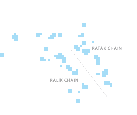
Majuro Water Resources Situation Assessment, Republic of the Marshall Islands

Project Fact File
Site Majuro
Water Issues Limited water resources, financial and human resources. No updated data and no metering or logging of bulk flow and pressure, no active leakage detection programmes.
Water Solution Capacity building, equip the utility with needed software and hardware to improve data collection, implement active leakage detection programmes.
Cook Islands

The Marshall Islands is one of only four atoll nations on our planet, with a maximum elevation above sea level of only a few meters. By this very nature freshwater supply is limited to groundwater from underlying lenses, and rainwater harvesting. During climatic extremes like El Nino periods, desalination is an option that has been sourced through different aid agencies. Desalination needs a lot of energy and Marshall Islands relies totally on imported fuel for power generation, making the process too expensive and unsustainable in the long term.

These facts may lead you to believe that water demand management is a high priority at the national level in the Marshall’s. Unfortunately this is not so. During a scoping mission to Majuro by SOPAC in August 2006 several options for improvement were discovered *.

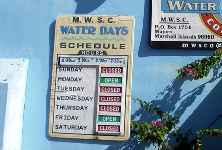
There is a lack of data and data -collection, -analysis and data storage options. The main utility, Majuro Water and Sewerage Company, (MWSC) are under-resourced in terms of both staff and finance, and training and capacity building needs are high. Their own legislation is weak and there is no overall water sector strategy for Majuro or other islands in the republic. These are some of the issues that, together with urbanisation, population growth, and resulting increased vulnerability from natural and man-made hazards, make minimising water losses a high priority.

By comparing the amount of water supplied against invoices for water received and paid for it is estimated that the leakage in Majuro’s water supply system could be around 50%. This is a very rough estimate and an unknown but assumingly large amount disappears through illegal offtakes. The NZAID funded Water Demand Management program has so far facilitated the participation of the Manager and one engineer from the utilities in Majuro and Ebeye to participate in a Water Loss Workshop held in Pohnpei in October 2007. The Marshall Islands have also access to their own leak detection equipment and a lap top to help out with data collection and to serve as a backup storage facility for water related information. In the near future it is hoped that, with the cooperation of MWSC the installation of new flow meters and loggers to monitor the whole reticulation system can be executed. Based on findings from the data collected so far it is further hoped to create a System Loss Management Plan in order to assist Majuro, and the Marshall Islands in general, to improve the management of this most precious resource; freshwater.

* (SOPAC EDF9 Reducing Vulnerability of Pacific ACP States – Republic of Marshall Islands KRA2 Technical Report No 86)